Mission to drill into Japan’s quake zone half a success

Part of the core from Japan's fault zone{credit}Japan Agency for Marine-Earth Science and Technology (JAMSTEC){/credit}

A mission to drill into the fault zone that caused the recent devastating earthquake in Japan has met with only partial success.

Researchers on board the Japanese drill ship the Chikyu were aiming to bore right through the plates that slipped during the massive 9.0 earthquake of 11 March 2011, pull up sediments and install temperature sensors down the hole. This, they hoped, would help to fill in some crucial blanks in models of earthquake behaviour — specifically, how much friction exists between sliding plates (see ‘Drilling ship to probe Japanese quake zone’). They got their core, but they didn’t manage to install the temperature sensors.

The problems were frustratingly simple: the cruise was repeatedly delayed by bad weather, and then the cable for their underwater viewing system malfunctioned, leaving drillers unable to see what they were doing. “This was the first time drilling was happening in such deep water,” says James Mori, a seismologist at the Disaster Prevention Research Institute of Kyoto University in Japan and joint chief of the expedition. “Such problems aren’t unexpected. Things happen when the pressure is that high.” Each time something went wrong, he notes, it would take about three to four days for the drilling rig to be pulled up and put back down again through 7 kilometres of water. “It was very frustrating. Very disappointing.”

Nevertheless, the team is celebrating: they set a new record for drilling in deep water (see ‘Drilling into Japan’s quake zone‘) and extracted core samples from 648–844.5 metres below the seabed, right across the fault zone as hoped (see press release). As usual, some parts of the core crumbled and were lost before they could be pulled on board — they retrieved about 40–50%. This is actually a good hit rate for this sort of mission, but it means the team doesn’t yet know whether they have core samples from the crucial bit that slid during the recent quake. Either way, the cores should help to shed light on the physical properties of fault-zone sediments, says Mori.

The researchers haven’t yet given up on the idea of taking the fault’s temperature. It looks like they might be able to get another slot on the Chikyu in July or August, says Mori. They can reuse the same wellhead, but will drill a new hole and try to get the temperature sensors down again. That means their temperature record will start months later than hoped, but it shouldn’t be too late to be useful, he says.
Sound science policy center gets a million-dollar boost

UPDATED: 1 May @ 18:00

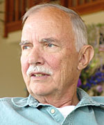
The Union of Concerned Scientists (UCS) has received a US$1-million donation from Lewis Branscomb (pictured), a physicist and former IBM vice-president, to set up a Center for Science and Democracy. The centre, to be launched on 17 May, aims to combine the Cambridge, Massachusetts-based union’s previous work beating back political interference in federal science, with an ongoing mission to ensure that US policy is based on sound scientific evidence.

“Lew Branscomb is obviously a giant in the science policy world and has been active for a long time, so if some of his efforts rub off on the UCS, then that would be a good thing,” says Roger Pielke Jr, who works with the Center for Science and Technology Policy Research (CSTPR) at the University of Colorado in Boulder and is not involved with the UCS effort.

There are already innumerable programmes focused on science policy in the United States — including the CSTPR — but Pielke says that there’s plenty of room for more. “We do not want to replicate what others are already doing well,” adds UCS president Kevin Knobloch. “We’ll be a hybrid between a university and a think tank, and more aggressively apply the scholarship.” The American Association for the Advancement of Science also has a science-policy effort, but it focuses mainly on budget analysis, says Pielke.

The centre has so far raised $1.5 million for work over 3 years from private donors, and aims to eventually ramp up to a budget of $4 million a year. It will be hosted at current UCS offices with perhaps a dozen full-time staff, says Knobloch. They are hiring a director now.

The centre’s duties will include enlisting speakers from outside the science community, such as educators, religious leaders and chief executives, who can speak to the value of science in governance. It will also host 2–3 forums a year, where invited experts will speak to specific topics and help to hash out recommendations for action. These might focus on, for example, the challenges around communicating climate science, or the over-dependence of the US Food and Drug Administration on user fees from the pharmaceutical industry.
Continue reading

Mexican volcano spits ash and rock

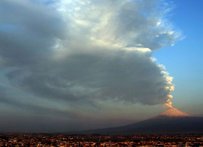
A volcano some 60 kilometres from Mexico City has been throwing out ash and hot, glowing chunks of rock since 12–13 April.

This activity isn’t particularly unusual — Popocatépetl (whose name comes from the Aztec for ‘smoking mountain’) is one of Mexico’s most active volcanoes. In 1994 it started belching again after more than 50 years of relative quiet, erupting in 1996 and 2000. The 2000 eruption was accompanied by an evacuation of 50,000 people.

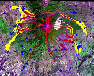
“There’s not a huge danger from the present activity as it is,” says James Gardner, a volcanologist at the University of Texas at Austin, who has worked on the volcano. “But there’s good reason to keep an eye on this one.” Even small explosions can send out ash that, if the wind is right, can close Mexico City’s international airport, Gardner says. And the volcano, along with its ice cap, is capable of producing massive lahars or mud flows. The last serious eruption was 500 years ago, he says. A hazard risk map produced in 2001 by Mexican and US researchers shows that such flows could hit populated areas, but definitely not Mexico City (see here for full-size map. The blue areas are cities and towns; red and yellow are flood zones of different severity).

There is “good, capable” scientific monitoring of this volcano to keep people informed of the risk, says Gardner. Popocatépetl Volcanological Observatory was luckily founded in 1994, just a few months before it started rumbling. This includes some 15 remote field stations around the volcano, with seismometers, tiltmeters, and video cameras for real-time monitoring.

For now, local officials at the Mexican National Centre of Disaster Prevention have put out a yellow alert (their third-highest warning) for the volcano, which has about 500,000 people living in its vicinity. People are being asked to stay at least 12 kilometres away. Locals in towns where the ash is falling, including Puebla, are being told to cover their mouths and clean debris from weak rooftops to avoid building collapse.

You can find updates on global volcanic activity, including this one, through the Global Volcanism Program.

Photo: AP/Press Association Images, Map: National University of Mexico (UNAM), University at Buffalo

Oil-sands mining carves up carbon sinks

There has been much debate about the environmental damage being done by oil-sands mining in Alberta, Canada, from the carbon emissions to the water pollution produced by the energy-intensive process. Now an Albertan scientist well known for his concerns about the industry weighs in with another factor: the destruction of peatlands.

David Schindler of the University of Alberta and his colleagues note that industry plans for the oil-sands region will eliminate some 29,500 hectares, or 65%, of local peatland habitat —  a wet, boggy terrain that is rich in decaying organic matter. This will force the release of 11 million–47 million tonnes of carbon now stored in the peatland (about 7 years’ worth of emissions from the mining process) and the reduction of sequestration potential by 5,700–7,200 tonnes of carbon a year, they calculate in a study published today in Proceedings of the National Academies of Science (PNAS). By comparison, burning all the proven oil-sands reserves would release 22 billion tonnes of carbon, and thawing permafrost could release 30 billion–60 billion tonnes of carbon by 2040.

Schindler points out that the industry and the media often seem to assume that mined land will be returned to its original state: the Canadian Association of Petroleum Producers (CAPP), for example, writes on their website that they aim to help return land “to a sustainable landscape that is equal to or better than how we found it”. Schindler and his colleagues call this “greenwashing” in their PNAS paper, noting that, at present, no industry reclamation plans call for restoring peatlands, but call instead for generally replacing wetlands with drier forests and pit lakes to cover tailing ponds. “Industry’s obligation is to restore the land to a sustainable condition: a similar but not identical state,” wrote CAPP vice-president Greg Stringham to Nature. “We have not said we will restore peatlands, although we are working on it.”

An independent review of the oil-sands operations by the Royal Society of Canada came to a theoretically more optimistic conclusion about land reclamation in 2010 (see Impacts of Canada’s oil-sands operations ‘exaggerated’).  That report states: “The potential for successful reclamation of wetlands, particularly peatland, has not been well demonstrated in the research to date although studies elsewhere indicate more feasibility than generally believed.”

Schindler has been a prominent voice calling for improvement of monitoring and regulation in the oil-sands industry (see Tar sands need solid science). “The oil sands reclamation is about the same quality as their monitoring,” says Schindler now. New monitoring programmes have recently been set up (see Oil sands monitoring plan gears up).

Last month, climate scientists startled some observers by saying that theoretical carbon emissions from the oil sands weren’t as big as they had suspected: they estimated that burning all the oil that might reasonably be extracted from Alberta’s sands would raise the global temperature by just 0.02 degrees Celsius (See Canadian oil sands: Defusing the carbon bomb). This estimate has been criticized, however, for not including the fact that the oil sands take a lot of energy to extract in the first place, making it two to three times ‘dirtier’ per barrel than other types of oil production.

Several mining companies are considering steam reforming the oil, which would allow them to extract it without making as much of a dent to the surface landscape. But this process takes yet more energy, so would worsen greenhouse-gas emissions.

Photo credit: Paul Sanborn, University of Northern British Columbia

Ocean health index devised

Can a single number represent the health of an ocean? Researchers think they have cracked a method to do just that, they reported at the American Association for the Advancement of Science meeting in Vancouver this weekend.

The ‘Ocean Health Index‘, devised by a consortium of more than 60 international scientists, aims to integrate measures of all kinds of ocean fitness, from a water body’s ability to support local jobs to endemic species. The effort is part of a growing movement to quantify ecosystem health in order to help policy-makers set priorities and measure improvements, just as single financial measures, like Gross Domestic Product, compress a mass of complex data into a single number for tracking purposes. “It’s GDP envy” that makes ecologists attempt projects like this, says Ruth deFries, an ecologist at Columbia University in New York who was at the meeting but is not involved with this project.

The index is composed of ten categories: food provision, clear water, natural products (from pharmaceuticals to fish oils), artisanal opportunities (meaning the chance for families or small businesses to fish for themselves), carbon storage, coastal protection, sense of place (a category that accounts for the presence of iconic species or the ‘special’ nature of a place for the local community), livelihood (its contribution to the local economy and jobs), biodiversity, and tourism and recreation. Each category is ranked out of 100 on its present status compared to a reference state, and from –100 to +100 on three factors assessing its likely future state. “That’s a quantification of sustainability,” says Benjamin Halpern, a biologist at the University of California at Santa Barbara and lead researcher for the project. This results in a score for each of the ten measures. The categories can then be weighted (the default is to weight them evenly) and a single number pops out.

Although there are a host of subjective decisions that go in to each assessment, Halpern insists that he and his colleagues tried their hardest to make it as scientific and reproducible a method as possible. Only global data sets are used, so that one site’s assessment will be comparable to another’s. And rules have been set about which data sets and which reference points to use. “I guarantee someone will criticize it for being subjective, but I can’t think of a more objective way to do it,” he says.

Whoever uses the index will have to disclose which data sets they used, what scores they gave and how the categories were weighted, giving a fuller sense of the ocean’s health. “We don’t just need a ‘Dow Jones’, but that plus all the bits you’d need if you were a broker,” says project participant Andrew Rosenberg of Conservation International in Washington DC. “It’s an integrated measure, but it can be unpacked.”

The group has used their methodology to evaluate the exclusive economic zone of every country around the world — and more than once for some countries, such as the United States, which borders on several oceans. These ranked scores, along with a detailed description of the method, are in a paper now undergoing peer review. The assessment was a massive project: the description of how they crunched the data is 120 pages long, says Karen McLeod, a co-author of the work and director of science for COMPASS, a group that helps scientists communicate with policy-makers. They had hoped to unveil the scores at this meeting, but will have to wait for publication before doing that. “In some ways, that’s a good thing,” says McLeod. Once the numbers are out, the team anticipates a lot of squabbling about who deserves a higher or lower score, rather than a sober assessment of the method, she says.

Photo: Vancouver Harbour illustrates the diversity of human-ocean interaction.

Oil sands monitoring plan gears up

A plan for monitoring the environmental impacts of Canada’s oil-sands operations now has a roadmap for its implementation. More important, commentators say, is whether there will be an additional move to have an independent panel, rather than government or industry watchdogs, oversee that monitoring.

Diana McQueen, who was recently appointed environment minister for the province of Alberta, where the oil sands are located, has said she agrees with this idea and will work towards it. University of Alberta researcher David Schindler, who has drawn attention to the problems of run-off from the oil-sands operations affecting fish and water quality (see ‘Tar sands need solid science‘), is impressed. “I think they’re sincere in their efforts to move management of this to an independent panel. That’s the battle that’s been won,” he says. “I’ve been invited to come and discuss the panel’s makeup with the provincial government,” he adds.

Continue reading

Simple tools speed up quake warnings

Sendai_Earthquake_2011Researchers have developed a new technique for quickly assessing the magnitude of large earthquakes, cutting down the time required in the case of the recent quake in Japan, for example, from about 20 minutes to just 2-3 minutes. Those crucial minutes would have helped with tsunami warnings and in making sure that even far-away communities like Tokyo had proper alerts as soon as possible, says Yehuda Bock of the University of California, San Diego, who developed the technique.

The strategy involves tying together real-time data coming from seismic instruments, which detect shaking, as well as Global Positioning System (GPS) instruments, which detect the absolute movements of the ground. Both devices are already installed in places such as Japan and California — the key is to ensure that they are delivering the right sort of data simultaneously, says Bock, who reported on his progress at the American Geophysical Union (AGU) meeting in San Francisco, California, on 8 December. Bock and his colleagues this month received funding to build and test a prototype upgrade device, and hope to have an initial system in place in California within six months.

Seismic instruments are very sensitive, but have a hard time discriminating between large quakes of magnitude 7 or higher in the first seconds or minutes of an earthquake, because the shaking simply goes off the scale. In the case of the March 2011 Tohoku earthquake in Japan, for example, the Japan Meteorological Agency estimated the quake’s magnitude as just 6.8 after 38 seconds, and 8 after a few minutes, says Bock. It was not until weaker seismic readings from much further away were added to the analysis that they could say, 20 minutes after the quake began, that it was a devastating magnitude 9 — 30 times stronger than a magnitude-8 quake.

Continue reading

Hole in the ground available for hire

safodWhen researchers drilled a hole into California’s San Andreas fault, they dropped a string of instruments down into its depths in 2008 that they hoped would take readings of seismic and magnetic activity for years. But that experiment, called the San Andreas Fault Observatory at Depth, failed just days into its run. Last year, when researchers pulled the instruments back up for examination, they brought with them a batch of stinking mud and some bad news. Analysis of the string suggested that these sorts of instruments just aren’t up to surviving in the hot, acidic conditions down the hole, says National Science Foundation (NSF) EarthScope programme director Greg Anderson — at least not with the technologies available at present. “It will take years before we might try again,” he said at the American Geophysical Union meeting in San Francisco this week.

The good news is, this means that the hole is now free for use by anyone who wants to put in a proposal to use it — and not just for disposing of lazy grad students or rejected papers. Shorter-term projects or more ‘passive’ instruments would probably survive the conditions, says Anderson. Principal investigators keen on trying their luck need simply submit plans to the NSF. “We’re open to proposals,” he says.

Western Himalayan region faces big quake risk

jhelum.jpgThe Kashmir region in northwestern India could experience a magnitude 9 earthquake — several times larger than previously assumed. The revised risk estimate is worrying, says Roger Bilham of the University of Colorado, Boulder, who presented the results on 7 December at the American Geophysical Union meeting in San Francisco. “There are many cities and megacities in the region. And there are a couple of nuclear power plants there too,” he says. “You have two nuclear powers facing each other, armed to the teeth, facing a huge amount of damage”. Bilham speculates that perhaps 300,000 people might die in such an earthquake, not counting subsequent problems from political turmoil between India and Kashmir, or flooding.
[image: the Jhelum River in Kashmir could flood from a quake-triggered landslide]

Continue reading

Fracking caused British quakes

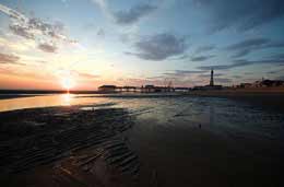
Blackpool.jpgA UK energy company has admitted that their hydraulic fracturing project (commonly known as ‘fracking’) probably caused a few surprisingly large earthquakes in Lancashire this spring. But, their report into the events concludes, it should be safe to continue operations in the area. Protesters disagree.

Fracking involves pumping millions of litres of water underground to fracture shale rock, allowing natural gas trapped inside to flow up the well. Concerns have been raised about whether this technique is safe (see Should fracking stop? and United States investigates fracking safety).

Two quakes of magnitude 2.3 and 1.4 in April and May, along with a cluster of 48 much smaller events, struck near the fracking project of Lichfield-based company Cuadrilla Resources. Cuadrilla stopped operations, and commissioned independent reports from a handful of consultants, including a Czech Republic seismic company and a British geomechanical services company, to investigate whether the drilling had triggered a nearby fault. Their synthesis report is now out.

Continue reading