Tragedy strikes Taiwanese research ship

TAIWAN-ACCIDENT

The sinking of the Ocean Research V in an image from a video released by Taiwan’s Coast Guard.
{credit}Taiwan Coast Guard/AFP via Getty{/credit}

Two scientists died on 11 October after the research vessel they were on, Taiwan’s Ocean Research V, capsized in the Taiwan Strait. Another 25 scientists and 18 crew members were rescued. 

The 73-metre, 2,700-tonne vessel, which had been operating only since February 2013, cost 1.5 billion new Taiwan dollars (US$50 million). It had three laboratories, sonar for seafloor mapping, multiple plankton samplers and other devices for comprehensive ocean exploration. It was built to carry out scientific and as well as resource surveys, including sampling sea-bed gas hydrates and offshore wind turbine sites.

The Ocean Research V was also equipped with a dynamic positioning system to enable it “to conduct highly precise action on sea even under strong winds in the situation of typhoon or strong monsoon“, according to the Taiwan Ocean Research Institute, which operated it. But on the night of 10 October, one day after setting sail, the ship capsized near Penghu island, some 50 kilometres off of Taiwan’s western coast. Some speculate that it hit a reef after being blown off course by strong winds related to a typhoon. 

Hsu Shih-chieh, a researcher at the Academia Sinica in Taipei, reportedly died after making efforts to save his fellow researchers. Lin Yi-chun, a scientist at the Taiwan Ocean Research Institute, also died.

The Ministry of Science and Technology is now investigating the cause of the accident.

Indian Ocean signal was not crash of flight MH370

Posted on behalf of Declan Butler.

nature-MH370map-050914.jpg

Hopes have faded that hydroacoustic signals picked up on the floor of the Indian Ocean might help to locate the Malaysian Airlines flight MH370 airliner that disappeared in March. Data from an additional sensor suggest that the signal probably resulted from geological activity and not the sound of an aircraft crashing into the ocean’s surface.

In June, Australian scientists had reported that sensitive microphones off the Australian coast had detected a distinctive signal at 01:30 coordinated universal time (UTC) on 8 March, around the time satellites lost contact with the Boeing 777 airliner.

The initially reported signals were discovered by an ocean acoustics group at Curtin University’s Centre for Marine Science and Technology in Perth, Australia. They were studying data from an acoustic station in Perth Canyon, about 40 kilometres west of Rottnest Island off the country’s west coast (see ‘Sound clue in hunt for MH370′).

That station is one of six belonging to Australia’s Integrated Marine Observing System (IMOS). The team then confirmed the signal using data from the Cape Leeuwin acoustic station, operated by the Comprehensive Nuclear-Test-Ban Treaty Organization (CTBTO) southwest of Australia. This gave a rough fix on the location of the origin of the sound as somewhere along a strip in the northwest of the Indian Ocean (see ‘Lost trail’).

On 3 September the researchers recovered data from another IMOS station at Scott Reef, off northwestern Australia. It contains a signal at 01:32:49 UTC that the researchers believe could correspond to the sound event they had detected earlier. Combining the data gave a fix on the location of the sound as the geologically active Carlsberg Ridge, midway between the Horn of Africa and India.

The sound signal also had a low amplitude tail, and taken together these two findings suggest that the event was geological — caused, for example, by an earthquake, underwater landslide or volcanic eruption, says Alec Duncan, a scientist in the Curtin University group.

Indian court halts projects in wake of calamitous monsoon

Posted on behalf of Sanjay Kumar.

In a judgement with far-reaching consequences, India’s Supreme Court on Tuesday put a moratorium on the construction of new hydroelectric dams in the Himalayan state of Uttarakhand.

The region witnessed unusually heavy rain and catastrophic floods and landslides in mid-June that left more than 5,000 people dead or missing. Some ecologists and geologists suggested that a proliferation of dams and hydroelectric projects was in part to blame for exacerbating the effects of the monsoon.

The court’s findings reflected those concerns, describing the “mushrooming of a large number of hydroelectric projects in Uttarakhand” and their impact on the basins of the Alaknanda and Bhagirathi rivers, the two major tributaries that merge to form the Ganges River.

The court ordered the environment ministry and the Uttarakhand government “not to grant any further environmental or forest clearance for any hydro-electric power project in the state until further orders”.  It also mandated fresh scrutiny of the environmental impact of 24 proposed hydropower projects.

The court referred to a study commissioned by the environment ministry and conducted by the government-funded Wildlife Institute of India (WII), based in Dehradun. That study reported in 2012 that out of total 39 proposed hydroelectric projects it examined, 24 had significant impacts on biodiversity in the two sub-basins. If all of these proposed projects were to reach completion, a significant area of fish habitat would be modified or lost, affecting 87% of the fish species in the basins, the study found.

Several projects that have been proposed or that are already under construction would impact the remaining wildlife habitats of the snow leopard, brown bear, black bear, Tibetan wolf and musk deer, the WII warned.

Critics of the government such as the non-profit think tank South Asia Network on Dams Rivers and People point out that more than 300 projects are operational, under construction or proposed in Uttarakhand alone — and that for all of India’s Himalayan range the number exceeds 1,600. The government of Manmohan Singh has been overriding environmental and scientific concerns to expedite the approval of stalled projects.

The court has now directed the environment ministry to set up an expert body comprising representatives of the state government, the WII, the Central Electricity Authority and the Central Water Commission to study the environmental impact of hydroelectric projects that are in existence or under construction, to find out whether they played a role in the June disaster. The committee is supposed to report back in three months.

Russian meteor blast was the largest ever recorded by CTBTO

https://youtu.be/duD0b1UMAnA

The blast on 15 February over the Urals Mountains of a fireball that had entered the Earth’s atmosphere over the Kazakh-Russian border was the largest explosion ever recorded by the Comprehensive Nuclear-Test-Ban Treaty Organization (CTBTO), according to the first detailed analysis of the event. The result is consistent with rougher, early estimates first reported by Nature (see ‘Russian meteor largest in a century’).

Twenty infrasound monitoring stations around the world registered the explosion, scientists report in a paper accepted for publication in Geophysical Research Letters (abstract here). A meteor explosion on 8 October 2009 over Indonesia had been recorded by 17 stations.

Some 460 kilotonnes of trinitrotoluene (TNT) equivalent — almost ten times the energy of the 2009 Indonesia event — were released when the 9,000-tonne object exploded over the Urals city of Chelyabinsk, injuring more than 1,000 people. It was the most energetic confirmed airburst since the explosion in 1908 of the Tunguska meteor over Siberia, which is estimated to have packed between 3 and 5 megatonnes of TNT equivalent. Fireball events in the order of 500 kilotonnes of explosive energy occur, on average, every 75 years.

The team reports that infrasound signals of the Chelyabinsk explosion circled twice around the globe and were recorded until almost 3 days after the event. The data on infrasound propagation can be used for calibrating the performance of the international monitoring network designed to detect violations of the nuclear-test-ban treaty that came into force last year.


Quake off eastern Russia may be biggest-ever deep temblor

okhotsk quake An extraordinarily deep earthquake shook Russia’s Far East this morning. The magnitude-8.3 quake took place nearly 610 kilometres below Earth’s surface, according to preliminary estimates from the US Geological Survey.

Normally rocks at this depth are too hot to rupture quickly in a quake; instead, they deform slowly, like hot wax flowing rather than cold wax shattering. But beneath the Sea of Okhotsk, north of Japan and west of Russia’s Kamchatka Peninsula, the sea floor — a slab of old Pacific crust — is diving beneath Eurasia. The crust is descending fast enough — about 8 centimetres per year — to remain cool enough to rupture even at great depths. The diving plate is thus seismically active down to 650 kilometres or greater.

The epicentre of today’s quake was about 400 kilometres northwest of the seismiccity of Petropavlovsk-Kamchatsky. Deep quakes cause less damage than shallow ones, and early news reports suggest that injury and damage were minimal, although the shaking was felt as far away as Moscow. (Pictured, at right, is the seismic signal as recorded in Ruedersdorf, Germany.) A tsunami warning was issued and lifted soon thereafter.

A series of smaller quakes, up to about magnitude 6.0, had shaken just south and east of Petropavlosk-Kamchatsky over the past several days. But they were far shallower. Figuring out how the shallow earthquake swarm and the large deep quake are related — if they are — is likely to be a topic of intense study.

The Okhotsk quake rivals and perhaps surpasses the magnitude-8.2 quake that hit northern Bolivia on 9 June 1994. That one occurred 631 kilometres deep, reshaping geologists’ ideas about how earthquakes could occur so far down.

Images: USGS; GFZ

Seismic fault’s temperature implies deadly earthquake involved low friction

Researchers have come a step closer to understanding how and why the earthquake and tsunami that devastated Japan in 2011 were so surprisingly big. Temperature sensors installed in the fault last year now show that friction between the rocks during the quake was an order of magnitude smaller than previously assumed.

The magnitude-9 Tohoku earthquake shocked the research community by setting a record for the greatest amount of slip ever seen in a fault: some 40–80 metres. No one could explain how or why this happened. In late 2011, a group of researchers mounted a ‘rapid response’ effort to investigate (see ‘Drilling ship to probe Japanese quake zone’).

In the spring of 2012, they managed to install a suite of 55 temperature sensors more than 850 metres into the fault, which itself lies under 6,900 metres of water. Creating an observatory at those depths was in itself a record-breaking achievement. The project faced many challenges: bad weather delayed the installation, shifts in the fault could have crushed the instruments and an earthquake in December could have buried the observatory with landslides. But the team managed to retrieve their sensors on 26 April.

“Amazingly, it seems like the experiment might have actually worked,” says team member Emily Brodsky of the University of California, Santa Cruz. She and a colleague presented their preliminary results at the Japan Geoscience Union Meeting on 19 May.

The temperature measures show how heat dissipated from the fault over time, enabling the researchers to extrapolate back to the moment of the earthquake and to see how much frictional heat was generated during the shift. From this they calculated the coefficient of friction for the fault, and found it to be an order of magnitude lower than the conventional value that has been used since the 1970s. That lower number means less friction.

The result supports the theory that the friction during an earthquake can be dramatically different from the friction during quiet times, perhaps because water in clays is heated by a quake’s shaking, then expands and jacks open the fault. Brodsky says that there are hints that this finding could be generalized to other faults.

The result is consistent with experiments being conducted by Brodsky’s collaborator Kohtaro Ujiie of the University of Tsukuba, who has been trying to recreate the pressure and temperature conditions of this fault in the lab. Both groups hope to publish their results soon.

Italian seismologists appeal L’Aquila ruling

Posted on behalf of Nicola Nosengo.

Seven scientists, engineers and government officials who were found guilty of manslaughter after the 2009 earthquake in the city of L’Aquila, Italy, all filed their appeals against the verdict in time for a 6 March deadline.

The appeal trials will again take place in L’Aquila, but the court will consist of three judges instead of one as in the first-degree trial. The sentences — which include a six-year prison term and a permanent ban from civil service — will not become effective in the meantime.

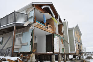
On 31 March 2009, the convicted scientists participated in a meeting of an expert panel on seismic risk held in L’Aquila, where earthquakes of low and medium intensity had been occurring for four months.

According to the prosecutors, the experts underestimated the risk that a major shock might be on its way, and some of them made exceedingly reassuring statements to the press, implying that a strong earthquake would surely not happen.

As a result, the prosecutors argued, on 6 April 2009, when a magnitude-6.3 quake occurred, 29 people who would otherwise have fled their homes during a tremor decided to stay inside and were killed when the houses collapsed.

On 22 October 2012, judge Marco Billi found the seven guilty of manslaughter and sentenced them all to prison terms of six years.

Billi explained his decision in an 800-page document made public on 18 January. He wrote that the defendants had conducted a “superficial, approximate and generic” risk analysis. Although they could not predict the earthquake, he wrote, they should have highlighted more clearly the probability of a strong shock and its possible effects, because they knew about the frailty of many buildings in the area.

Billi also wrote that they are all responsible for the reassurances that eventually reached the public, because no one contradicted the statements made to the press by some panel members.

In their appeal requests, the attorneys for the seven scientists ask for the verdict to be overturned and all charges to be dropped.

In response to Billi’s document they note that the statements made during the meeting were all scientifically accurate, and that informing the population was the responsibility of political authorities, not the panel members.

The lawyer of Giulio Selvaggi, former director of the National Earthquake Center at Italy’s National Institute for Geophysics and Volcanology, and others also criticize Billi’s use of scientific evidence.

His appeal request says that the judge used “brief parts of scientific papers or single tables […] to draw general conclusions”, and that “many scientific statements made in the verdict are not supported by the vast literature available”. For example, the lawyer questions the idea that strong earthquakes in L’Aquila have always been preceded by minor shocks.

Mostly, the appeals rebut the causal link at the heart of the sentence: that the 31 March meeting was the only reason the 29 victims were sleeping in their homes on the night of the earthquake, and that they surely would have been elsewhere had they not heard reassuring information from the panel.

According to the defendants, this link cannot be proven. “The sentence is self-contradictory and illogical,” Selvaggi told Nature. “The appeal is really about logic and cause-and-effect relationships, not about legal quibbles.”

Canada launches first asteroid-hunting space telescope

Posted on behalf of Brian Owens.

{credit}Janice Lang, DRDC {/credit}

The first satellite designed to search for and keep track of asteroids and space debris was launched into orbit today.

The Canadian Space Agency’s suitcase-sized Near-Earth Object Surveillance Satellite (NEOSSat) will circle the globe every 100 minutes, scanning space to pick out asteroids that may one day pose a threat to Earth.

NEOSSat will focus on the day side of the sky, which is not visible from ground-based observatories.  It is hoped that the mission will discover at least half of the asteroids 1 kilometre across or larger within Earth’s orbit.

The mission will also keep an eye on high-altitude satellites, and monitor orbiting space junk to try to minimize collisions. Tests of anti-satellite weapons and collisions between satellites have led to an increase in the amount of orbiting debris in recent years, leading to several near-misses with the International Space Station.

NEOSSat would not, however, have been able to provide advanced warning of the meteor that exploded over Russia earlier this month,  according to the Canadian Space Agency.

The new probe lifted off from from Satish Dhawan Space Centre in Sriharikota, India, riding on an Indian-made rocket together with other satellites.

Incoming! Russia feels meteor blast

https://youtu.be/duD0b1UMAnA

This morning, residents of the Chelyabinsk region of Russia saw an enormous meteor streak across the sky. Cars’ dashboard cameras captured one or more objects falling to Earth.

The strike is reported to have occurred around 03:25 UTC this morning, according to the Planetary Society, just before sunrise locally. Other videos record the shock wave from the meteor — probably either a sonic boom as it entered the atmosphere and/or the sound of it breaking up:

https://youtu.be/b0cRHsApzt8

There are reports of hundreds injured by broken glass across the region, and additional videos show apparent damage to some buildings.

It’s not entirely clear what’s caused the damage. The shock-wave video shows that it was a powerful burst that could have probably shattered windows on its own, but the New York Times reports that an impact crater has been found on the outskirts of a town 50 miles west of Chelyabinsk city. Meteorites are also reported to have rained down around the city of Satka, but these reports are unconfirmed.

The strike comes as an asteroid known as 2012 DA14 is about to pass Earth in a geosynchronous orbit, but initial reports make it sound as though the meteor or meteors are unrelated. Astronomer Phil Plait says that the trajectories simply don’t seem to add up — this meteor came from a different direction. The European Space Agency’s Space Operations Centre in Darmstadt, Germany, has tweeted that they believe the meteorite is unrelated. They’ve also posted a photo, taken by Meteosat-10, of the meteor’s vapour trail.


Hurricane Sandy relief bill clears first barrier, stirs debate

Relief funds could go towards man-made beaches and barriers around coastal cities such as Milford, Connecticut.{credit}Marilee Caliendo, FEMA{/credit}

The US House of Representatives on 15 January passed the second and third installments of a piecemeal Hurricane Sandy disaster-relief plan, adding about US$50 billion to the $9.7 billion in flood insurance funds that were authorized on 4 January.

Just a small amount of money would go to science agencies. The measure includes $136 million for the US National Oceanic and Atmospheric Administration (NOAA) to improve weather surveillance and forecasting capabilities, and $15 million for NASA to repair facilities damaged by the storm.

The Senate is expected to consider disaster aid legislation next week.

Hurricane Sandy relief discussions had been delayed since December, as House Republicans scrambled to reach a deal on the ‘fiscal cliff’, allowing an earlier Senate-approved $60.4-billion aid measure to expire. Many fiscal conservatives resisted rushing approval of costly long-term projects as part of an emergency-relief package. In recent weeks, as the House revisited the issue, legislators carved the package into three separate bills, as disagreements mounted over which projects to fund and at what cost.

The latest agreement includes $17 billion to address immediate recovery needs and $33.5 billion for longer-term efforts — including $2.9 billion for construction projects by the Army Corps of Engineers “to reduce future flood risk”. Some scientists have expressed reservations about supporting the restoration of coastlines and, especially, arming them further with levees, seawalls and man-made beaches.

Jeffress Williams, a retired US Geological Survey coastal geologist, says that the notion that coastlines will be rebuilt in a smart way is “just not realistic thinking”. He and a growing number of researchers believe that such physical barriers may disrupt coastal ecosystems and ultimately fail against the rising sea levels and more severe storms projected to result from global climate change.

Others worry that including such projects in emergency legislation will circumvent opportunities for scientific input. “We should make sure we’re absolutely vetting the projects to decide with very good science where it will work, where it won’t work,” says geologist Robert Young, who directs the programme for the study of developed shorelines at Western Carolina University in Cullowhee, North Carolina.